Explainers · 5 min read
First freeze of the season: what a freeze warning, freeze watch and frost advisory mean this weekend
Freeze warning vs frost advisory: what each NWS alert means, where the first freeze hits the Plains and Midwest on 16 and 17 October, and how to protect plants.
 By the Good Air team
In this article · 5 sections
A freeze warning means the National Weather Service (NWS) expects temperatures to fall below 32°F for long enough to kill some crops and plants. A frost advisory is one step lower: frost is expected and threatens sensitive plants, usually with lows of about 33 to 36°F (NWS, Understanding cold weather alerts). A freeze watch comes earlier, when a widespread freeze is possible in the next day or two.
This weekend all three are out. On the evening of Thursday 15 October 2026, Good Air's feed of NWS alerts held 52 freeze and frost alerts from NWS offices in 15 states: 18 freeze warnings, 33 freeze watches and one frost advisory. The first freeze of the season reaches the Plains and the Rockies' eastern foothills on Thursday night, and much of the Upper Midwest, Kansas and the Texas Panhandle on Friday night.
Freeze warning vs frost advisory vs freeze watch
NWS offices set their own exact thresholds, but the pattern is the same everywhere. The NWS office in Grand Forks, North Dakota, publishes typical criteria (NWS Grand Forks):
| Alert | What it means | Typical trigger |
|---|---|---|
| Frost advisory | Frost expected or occurring; sensitive plants at risk | Lows of 33 to 36°F across a zone |
| Freeze watch | A widespread freeze is possible | Freeze warning criteria possible 24 to 48 hours ahead |
| Freeze warning | A freeze is expected | Lows of 32°F or below across a zone |
| Hard freeze warning | A killing freeze is expected | Lows of 28°F or below across a zone |

The national NWS guidance explains why 32°F and 28°F matter. Temperatures below 32°F for a long period kill some commercial crops and garden plants, and temperatures below 28°F for an extended time can kill most of them. It says a freeze watch looks 24 to 36 hours ahead; some local offices, like Grand Forks, use up to 48 hours.
Freeze alerts are tied to the growing season. NWS Grand Forks says its growing season ends once at least half of a zone has had its first 32°F night of autumn, after which there are no tender crops left to warn about.
Where will it freeze this weekend?
The cold follows a strong cold front. FOX Weather forecast a temperature drop of about 40 degrees from earlier in the week, with highs in the Plains and Upper Midwest falling from the 80s on Thursday to the 40s and 50s on Friday, and lows in the 20s and 30s. It called Saturday morning likely the coldest of the season so far (FOX Weather, updated 14 October).
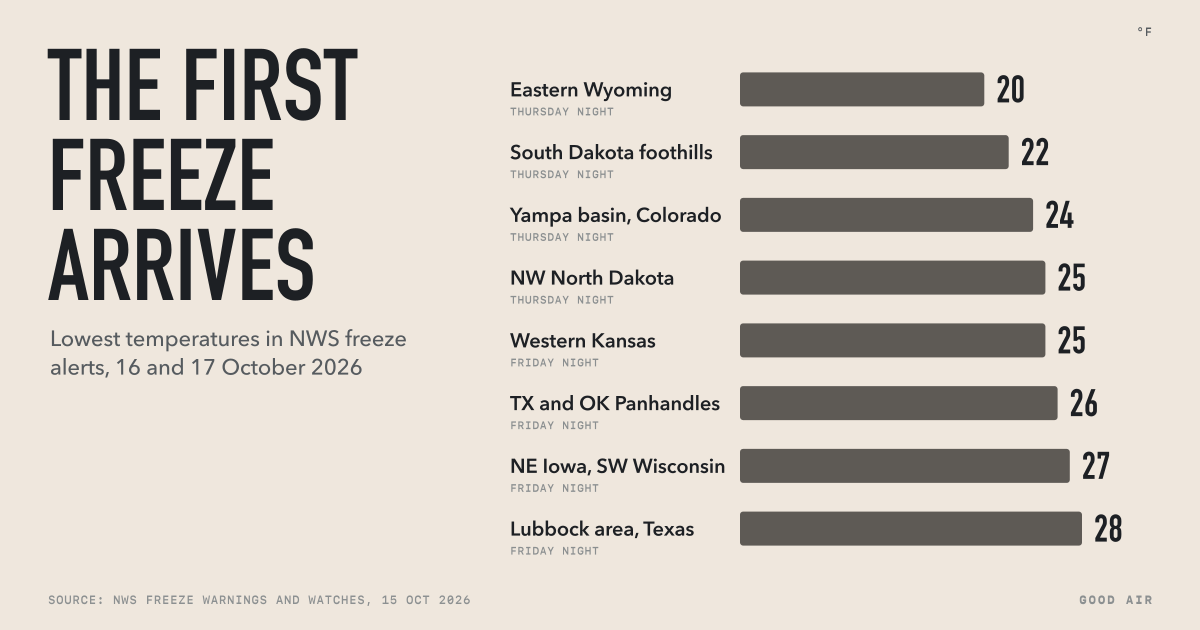
These were the coldest lows in the NWS freeze alerts on the evening of 15 October:
| Area (NWS office) | Lowest forecast | When |
|---|---|---|
| Converse and Niobrara counties, Wyoming (Cheyenne) | 20 to 25°F | Thursday night |
| South Dakota foothills (Rapid City) | 22°F | Thursday night |
| Bighorn Basin, Wyoming (Riverton) | 22 to 26°F | Thursday night |
| Yampa River basin, Colorado (Grand Junction) | 24°F | Thursday night |
| North-west North Dakota (Bismarck) | 25°F | Thursday night |
| Western Kansas (Dodge City) | 25°F | Friday night |
| Oklahoma and Texas Panhandles (Amarillo) | 26°F | Friday night |
| North-east Iowa and south-west Wisconsin (La Crosse) | 27°F | Friday night |
| Texas South Plains (Lubbock) | 28°F | Friday night |
| Denver and Boulder plains (Denver) | 26 to 32°F | Thursday night |
Source: NWS freeze warnings and watches via Good Air's alerts feed, 15 October 2026.
Further east, freeze watches for Friday night into Saturday cover parts of northern Illinois around Rockford (as low as 30°F), northern and eastern Iowa, western Iowa near Omaha, central Wisconsin (25 to 30°F) and southern Minnesota. The Weather Channel expected some of the season's first frosts and freezes as far east as the suburbs of the Northeast's I-95 corridor (weather.com, 15 October). Our US weather alerts page lists every alert that is active now.
Is this an early freeze?
Not for most of these places. NOAA's map of the median first fall freeze, based on 1991 to 2020 records, puts the first freeze in the Midwest between mid-September and early October, and in Colorado, New Mexico and Utah between September and November (NOAA NCEI, 23 October 2023). After an unusually warm start to October, much of the Plains and Midwest is catching up with its normal calendar.
It is a sharp swing all the same. Friday brings record highs and warm nights to parts of the eastern US, up to 20 degrees above normal for mid-October, before the front arrives (weather.com, 15 October). The cold won't last: forecasters expect warmth to return across the central and eastern US the following week, a "false fall".
How to protect plants, pipes and pets
The NWS advice in this weekend's alerts is short: "Take steps now to protect tender plants from the cold," and, where pipes are at risk, wrap, drain or let them drip slowly. In practice:
- Bring potted plants indoors or into a garage.
- Cover garden beds overnight with sheets or frost cloth reaching the ground, and remove them in the morning.
- Pick ripe tomatoes, peppers and squash before Friday night.
- Disconnect garden hoses and drain outdoor taps and sprinkler lines.
- Bring pets in overnight, and check that outdoor animals have water that won't freeze.
Cold mornings and air quality
Clear, calm, cold nights are the ones that bring frost, and they are also the nights when a temperature inversion forms: cold air sits at the ground under warmer air, trapping smoke and exhaust until the sun warms things up. If you light the first wood fire of the season, smoke can build up in your street overnight. The Denver air quality page and other city pages show the live reading. Our guide to PM2.5 vs PM10 explains what wood smoke adds to the air.
Wind is also part of this front. The NWS in Albuquerque paired its freeze alerts with high wind warnings and wind advisories, with gusts up to 55 mph, on 15 October. Dust lifted by strong winds raises PM10 readings. Our report on the Santa Ana winds covers the hot, dry wind events further west.
Frequently asked questions
What is the difference between a freeze warning and a frost advisory?
A frost advisory means frost is expected and may harm sensitive plants, usually with lows around 33 to 36°F. A freeze warning means the National Weather Service expects temperatures below 32°F for long enough to kill some crops and garden plants. A freeze warning is the more serious of the two.
What temperature is a hard freeze?
Many National Weather Service offices use 28°F or colder for a hard freeze, though thresholds vary by office. The NWS says temperatures below 28°F for an extended period can kill most commercial crops and garden plants, which is why a hard freeze usually ends the growing season.
What is a freeze watch?
A freeze watch means a widespread freeze is possible within the next 24 to 36 hours, according to the National Weather Service; some offices issue them up to 48 hours ahead. It gives time to protect plants and pipes. If the freeze becomes likely, the watch is upgraded to a freeze warning.
When is the first freeze of the season?
NOAA's 1991 to 2020 records put the median first fall freeze between mid-September and early October in the Midwest and Northeast, between September and November in the Rocky Mountain states, and later in the South. In 2026, freeze alerts covered much of the Plains and Upper Midwest on 16 and 17 October.
Should I cover my plants during a frost advisory?
Yes, if they are tender plants such as tomatoes, peppers, basil or flowering annuals. Cover them overnight with a sheet or frost cloth that reaches the ground, or bring pots indoors, and remove covers in the morning. Hardy plants and established shrubs usually survive frost without protection.