News · 5 min read
Nor'easter hits the Outer Banks: Hatteras visitors ordered out, NC 12 expected to close, 2 to 4 feet of flooding
A nor'easter brings 50 mph gusts, waves to 14 feet and 2 to 4 feet of flooding to the Outer Banks from 17 October. Who must leave, NC 12 and the worst tides.
 By the Good Air team
In this article · 6 sections
A nor'easter is moving in on North Carolina's Outer Banks from Saturday 17 October 2026, and Dare County has ordered all visitors off Hatteras Island. The county declared a state of emergency and a mandatory evacuation for visitors from 8 pm on Friday 16 October, covering Rodanthe, Waves, Salvo, Avon, Buxton, Frisco and Hatteras village, because it expects ocean overwash to make NC Highway 12 impassable (Island Free Press, 16 October).
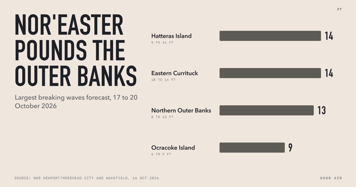
The National Weather Service (NWS) in Newport/Morehead City forecasts 2 to 4 feet of coastal flooding in low-lying areas, north winds gusting to around 50 mph and breaking waves of up to 14 feet, with the worst flooding on the high tides of Sunday and Monday, 18 and 19 October. No evacuation order covers residents, Ocracoke Island or the beaches north of Oregon Inlet.
Who has to leave the Outer Banks?
- Hatteras Island visitors: mandatory evacuation from 8 pm EDT on Friday 16 October, ordered by Dare County. Visitors should not travel to the island while the order is in force.
- Hatteras Island residents: no order, but the county expects NC 12 to be cut for an extended period.
- Ocracoke Island: no mandatory evacuation as of the evening of 16 October. Ferry officials said visitors leaving Ocracoke could still drive north through Hatteras Island on the Hatteras ferry until conditions stop it (Ocracoke Observer, 16 October).
- North of Oregon Inlet (Nags Head, Kill Devil Hills, Kitty Hawk, Duck): no evacuation.
After a 6 pm briefing on Friday, the NWS warned: "Saturday morning may be your last chance to get off Ocracoke and Hatteras Islands." Forecasters said people could be stranded for several days, which "could be life threatening if you have an emergency" (Island Free Press, 16 October).
Nor'easter forecast: wind, waves and flooding

These were the NWS alerts in force overnight on 16 to 17 October, from Good Air's feed of US weather alerts:
| Area | Alert | What is forecast | Until (EDT) |
|---|---|---|---|
| Hatteras Island, Ocracoke, northern Outer Banks, east Carteret | High Wind Watch | North winds 25 to 35 mph, gusts to 50 mph | Saturday evening to 2 am Monday |
| Hatteras Island | High Surf Advisory, Coastal Flood Watch | Breaking waves 5 to 14 feet; flooding in low-lying areas | 8 am Tuesday 20 October |
| Ocracoke Island | Coastal Flood Watch, High Surf Advisory | 2 to 4 feet of flooding above ground; waves 6 to 9 feet | 8 am Tuesday 20 October |
| Northern Outer Banks | Coastal Flood Advisory, High Surf Advisory | 1 to 3 feet of flooding; waves 8 to 13 feet | 8 am Tuesday 20 October |
| Eastern Currituck | High Surf Advisory, Wind Advisory | Waves 10 to 14 feet; gusts to 50 mph | 6 pm Monday 19 October |
| Mainland Dare, mainland Hyde, west Carteret | Wind Advisory | North winds 15 to 25 mph, gusts to 45 mph | 8 pm Monday 19 October |
Sustained winds are the average over a minute or two; gusts are the brief peaks. In a Friday afternoon briefing, the NWS put gusts at 45 to 55 mph on the islands, with the first high-tide concern around 1 pm on Saturday and more overwash possible on later tides. By Friday evening it said moderate oceanside flooding was likely and major flooding possible in vulnerable spots, and that it was more confident the impacts would last several days.
An NWS watch means a hazard is possible; an advisory means a less serious hazard is expected; a warning means a dangerous one is expected or happening. Several of these watches could become warnings over the weekend.
Will NC 12 close, and for how long?
Probably, though no one can say for how long yet. Dare County Emergency Management expects prolonged coastal flooding and repeated overwash to make NC 12 impassable on Hatteras Island. How long it stays shut depends on how long the storm lasts, the damage to the road and how quickly the North Carolina Department of Transportation (NCDOT) can clear and repair it. After a late-September nor'easter this year, NC 12 was closed for about five days.
The NWS warned that ferry disruptions could begin by Saturday evening and last into at least part of next week. Check NCDOT's ferry and road updates before travelling, and Dare County's bulletins; the county said its next update would come by noon on Saturday 17 October. Officials repeated the standard advice: "Never drive through flooded roadways or around barricades closing a road."
What is a nor'easter?
The NWS defines a nor'easter as a storm along the East Coast of North America, named for the north-easterly winds that blow in from the ocean over the coast. They are most frequent and most severe from September to April, and bring heavy rain or snow, gale-force winds, rough seas and sometimes coastal flooding (National Weather Service).
The Outer Banks are especially exposed because they are thin barrier islands with a single road. Days of onshore wind pile water against the beach, waves break over the dunes at high tide, and sand and seawater wash across NC 12. That is why the damage is worst on the high tides, rather than at the storm's peak wind.
How to prepare if you are staying
From the NWS and Dare County:
- Plan to be cut off. Residents should have food, water, medicines and fuel for several days, as the road and ferries may close.
- Move vehicles and belongings to higher ground before Sunday's high tides, and keep away from the beach and the surf zone; strong longshore currents can sweep people off their feet.
- Expect power cuts. The High Wind Watch says damaging winds could bring down trees and power lines, with widespread outages possible.
- Never drive through flood water or around road barriers. Salt water also ruins cars.
The same cold air behind the storm brings freeze watches to the mountains of western North Carolina and southwest Virginia for late Saturday night into Sunday morning. Our explainer on freeze warnings and frost advisories covers what to do for plants and pipes.
What does the storm mean for air quality?
Strong, steady north winds from the ocean usually keep the air clean on the coast, and air quality in the region was Good to Moderate before the storm, with Virginia Beach at 61 and Raleigh at 70 on the US AQI on the morning of 17 October IST. Flooding brings other risks: standing water can carry sewage and fuel, and damp homes grow mould within days. Our live US air quality page shows readings for cities across the region.
Frequently asked questions
Is there an evacuation for the Outer Banks?
Dare County ordered all visitors to leave Hatteras Island from 8 pm on Friday 16 October 2026, under a state of emergency declared ahead of a nor'easter. The order covers Rodanthe, Waves, Salvo, Avon, Buxton, Frisco and Hatteras village. No order covered residents, Ocracoke Island or areas north of Oregon Inlet as of 16 October.
When will the nor'easter hit the Outer Banks?
Conditions on the Outer Banks were forecast to worsen from Saturday 17 October 2026, with damaging north winds from Saturday evening through late Sunday night. The National Weather Service expected the worst coastal flooding on the high tides of Sunday 18 and Monday 19 October, with advisories running until 8 am on Tuesday 20 October.
Is NC 12 closed on Hatteras Island?
Dare County expected NC Highway 12 to become impassable during the October 2026 nor'easter because of coastal flooding and repeated ocean overwash, possibly for an extended period. Closure length depends on the storm's duration and road damage. NC 12 was closed for about five days after a nor'easter in late September 2026. Check NCDOT for the latest status.
How strong will the winds be in the Outer Banks nor'easter?
The National Weather Service's High Wind Watch for Hatteras Island, Ocracoke, the northern Outer Banks and east Carteret County forecast north winds of 25 to 35 mph with gusts up to 50 mph from Saturday evening 17 October 2026 through late Sunday night. An earlier briefing put gusts at 45 to 55 mph.
What is the difference between a nor'easter and a hurricane?
A nor'easter is a storm along the East Coast of North America, most common from September to April, named for its north-easterly winds. Unlike a hurricane, it forms outside the tropics, is usually larger and slower, and often lasts through several high tides, so it can cause long-lasting coastal flooding and beach erosion even with weaker winds.